
Sea-news.az reports that Farid Jafarov, Deputy Chairman of the Board of the State Cadastre and Register of Real Estate under the State Service on Property Issues (SSPI) of the Ministry of Economy, stated this during a briefing held on November 19.
According to him, this represents a fairly large territory:
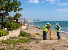
“However, under current legislation, those territories are already lands belonging to the sea’s water area, and they retain that legal status today. The coastal strip of the Caspian Sea was defined by the Cabinet of Ministers’ resolution dated August 24, 2016. That is, we refer to it as the zero line: the zero line of contact between the sea and the shore. Accordingly, protective zones have been established 20 and 50 meters inland from the coastline, and under current legislation, these territories are exclusive state property. Therefore, we will carry out mapping of the coastal areas.
Following the zoning of the Caspian coastal territories, the boundaries will be reflected on a digital map. Populated areas and zones designated for future settlement, as well as Baku Boulevard, the State Flag Square, ‘Sea Breeze,’ ports, and industrial parks, are not included within the scope of the new coastal management system. Their management is carried out within the framework of existing legislation. Once the zoning process is completed, every citizen will be able to see on the digital map which territories are included in the coastal management system.”